-


Follow Us

Keep in mind snow is falling all over the west, we're just covering the main resorts here that will pick up snow. The Pacific Northwest, N. Idaho, and Montana, will also see snow but will be too far north to see specific significant events worth forecasting; their snowfall will be a slow burn spread over the week and weekend. Likely not great chasing opportunities, but it will make for some excellent skiing especially near the end of the week.
The Tetons will get deeper with the flow aimed north into the Jackson Valley where JHMR and Targhee have already picked up decent totals since Sunday. Another area to watch is the higher peaks near Sun Valley where southerly flow favors the Wood River Valley (Dense snow adding up nicely though Wednesday at upper and mid elevations).
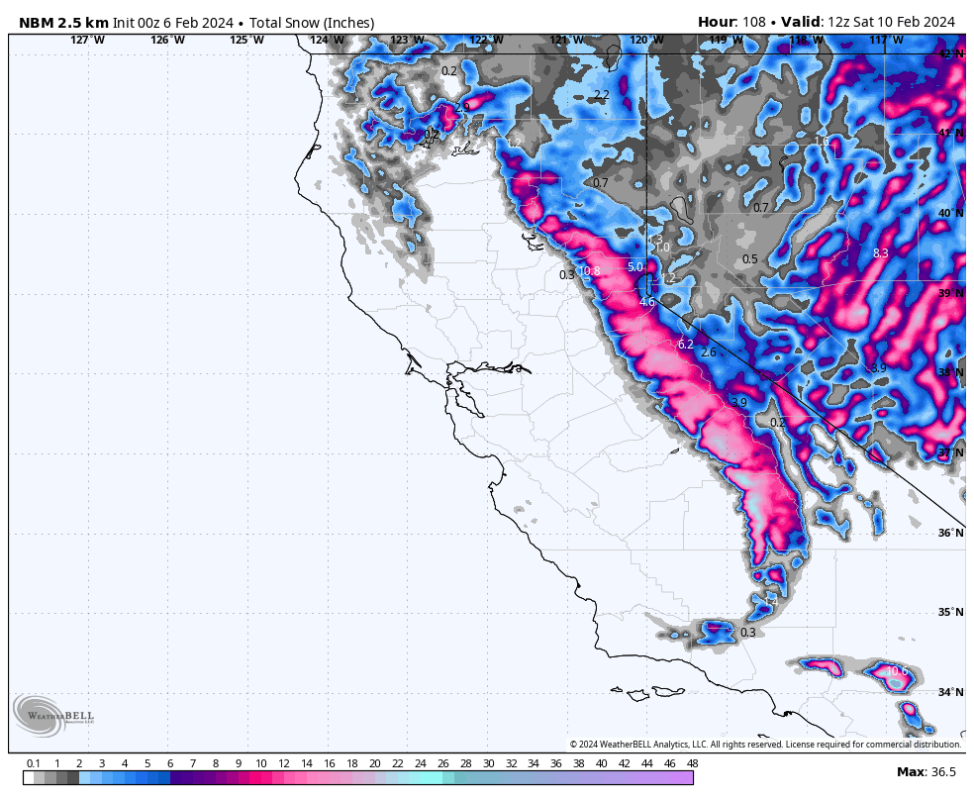
California
California is coming off the heels of a series of storms, with one still currently wrapping up as of Tuesday morning and will bring a couple more inches throughout the day.
Looking ahead, Wednesday, Thursday, and Friday should bring a several more inches; we're looking at sporadic light snow showers into the weekend, which won't make for great chasing but should keep the snow surface fresh and the snow quality good.
Below is the multi-model blend depicting our best numerical guess of snowfall from Monday night through Saturday (Slow refreshes with no single deep 24 hour event)
Utah
Precipitation will begin to pick up on Tuesday evening/night in Utah. Snowfall rates will peak early Wednesday morning before sunrise and continue at a moderate clip during the day (4-8).
Another wave picks up on Wednesday afternoon with colder temps that will linger into the weekend, likely Saturday morning. This will bring weekly storm totals up into the 20-30 inch range for the Cottonwoods (with good potential to exceed this), with 8-15" for resorts further north (Snowbasin, PowMow, Park City etc). These totals will be spread out over the week with several periods of light to moderate snowfall.
The best days for chasing this cycle in Utah will be Wednesday and Thursday, with the deepest overnight totals. Thankfully, winds will be low in Utah during this whole system, so after avalanche control, resorts should be able to operate lifts on the upper mountains.
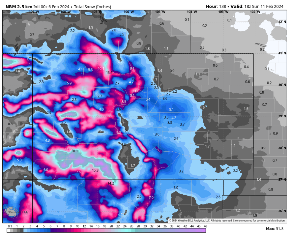
Colorado
Colorado will also do great with this storm system, with southern Colorado being heavily favored.
Precip will start in the San Juans on Tuesday afternoon and will intensify and fill in to the north overnight. Snowfall will linger into Sunday, with small bumps in snowfall rates during the afternoons.
By the time it's all said and done on Sunday, Wolf Creek will likely be at 35-45", easily the winner in the region. We're looking at 8-15" for the central mountains, 6-12" for I70 resorts (including Vail) and Steamboat (likely slightly more at Steamboat).
Wolf Creek will be the best chase day with the best day being Wednesday; significant snowfall overnight and steady snow throughout the day on Wednesday. Winds will be light so the upper mountain could operate on Wednesday if they are able to finish avalanche control.
Check out the model blend totals for Colorado below. You can see just how favorable the southern region of the state will be, but regardless, everyone wins!
Arizona/New Mexico
Arizona is going to see a surprising amount of snow, with the best day to chase double-digit totals falling on Wednesday across the state.
By Sunday, Arizona SnowBowl will see 15-25" and Sunrise Park, located to the southeast, should see 30-40". These are weekly totals with double digits most likely on Wednesday.
In New Mexico, Taos is going to be the winner, with 20-27" of snow likely by Sunday evening. The best day to chase should be Wednesday, Thursday, and Sunday. Winds will be high on Wednesday and Thursday, so the upper mountain will likely not be open.
Check out lower-atmospheric winds on Wednesday, with Arizona & New Mexico right under the bullseye. Not what you want to see if you want to ski the upper mountain!
More must-reads:
- NFL's active leader in games played wants to return for historic 20th season
- Blue Jays place struggling star OF on injured list
- The '2024-25 NBA steals leaders' quiz
Breaking News
Trending News


Customize Your Newsletter
 +
+
Get the latest news and rumors, customized to your favorite sports and teams. Emailed daily. Always free!

PRIVACY POLICY EDITORIAL POLICY CONTACT US
ABOUT YARDBARKER TERMS OF SERVICE
Use of this website (including any and all parts and
components) constitutes your acceptance of these
Terms of Service and Privacy Policy.
This site is for entertainment purposes only.
There is no gambling offered on this site.
Gambling Problem? Call 1-800-Gambler.