-


Follow Us

The past several days have been filled with high-quality snowfall with several feet reported in the Tetons (Wednesday to Friday) and a blue bird dry density powder day in the Wasatch Range. On Sunday radar and webcams showed heavy moisture bands have brought over 12 inches to Powder Mountain (Storm skiing). This has been an epic run of high-quality powder. That is all about to change as warming occurs initially with the next barrage of moisture.
Here is a video from Snowbird from Saturday morning with bluebird skies and some dry powder from Friday night.
Video (0:21)
@powderchasersteve (Instagram) grabbing some bluebird powder at the Bird Saturday. This was his 3rd consecutive powder day (Wyoming to Utah).
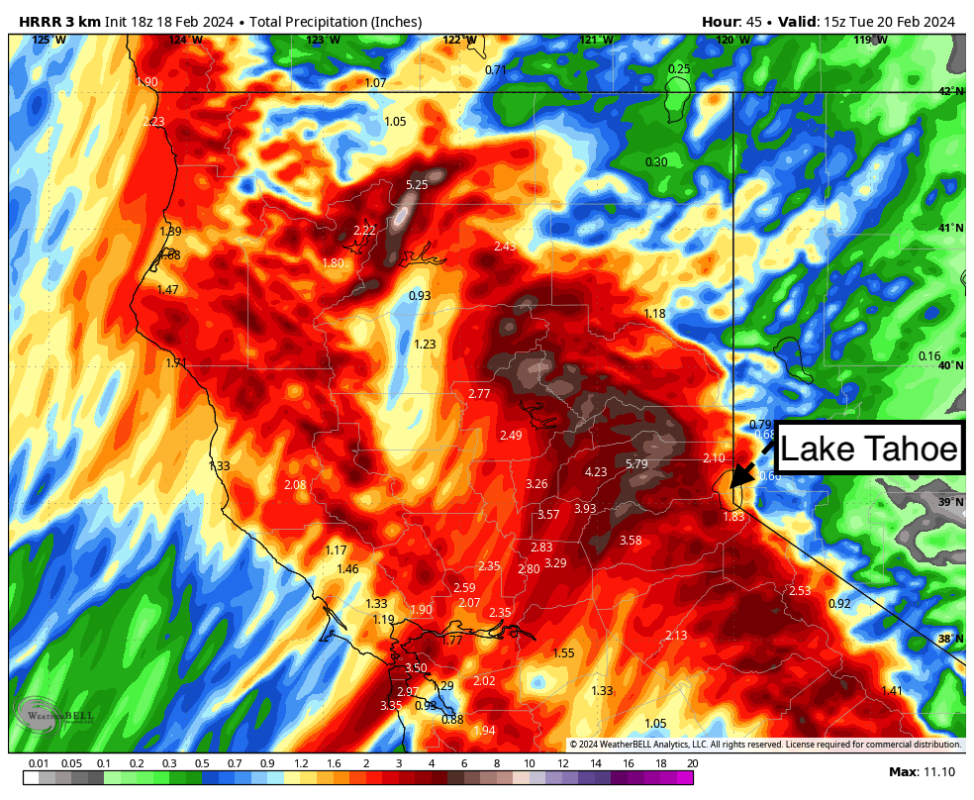
The heaviest push of snowfall for the Sierra Range will be Sunday night to Monday. The models differ in how much moisture with the American GFS showing up to 3 inches of liquid. The European is much less showing shadowing closest to the lake (Southerly winds are not ideal for Tahoe) with only an inch of liquid (This model is keeping most of the moisture west of the core of ski areas) The Short-term models indicate around 2 inches of water through Tuesday morning.
Averaging out the models, it is very likely that 2 inches of liquid fall at resorts favoring the west side of the lake through Tuesday morning. This should average out to around 24 inches of snow above 8000 feet with much less at lake level. We see higher totals possible for Mammoth (Higher elevation bonus), and Mt Shasta to the north.
Bottom Line Tahoe: Warm storm (Snow level 7,000) with very windy conditions Sunday night through Monday (Slight decrease Monday). Cooling occurs Monday mid-morning with lake-level snow likely. Snow densities will be very wet Sunday night migrating a bit lighter from Monday afternoon to Wednesday (Snow levels drop to around 5500-6500). Snow continues at a lighter pace Monday night into Wednesday. Storm totals through midweek might exceed 3 feet from several waves of moisture. The peak snow intensity will be Sunday night through Monday. Winds will likely be an issue Monday at upper elevations, as well as extensive AVY mitigation. We would not be surprised to see a few areas stay closed Monday.
Details on who grabs the deepest totals next will be addressed in a future post. Currently, we have high confidence in significant snowfall for the Wasatch Tuesday/Wednesday with dense snow migrating a bit lighter towards the tail end of the storm. Avalanche Danger will be rising. Expect some high totals by late Wednesday above 8,000 feet in Utah.
More must-reads:
- Oilers win defensive gem to go up 3-1 on Kings
- Four stars from Sunday's NBA playoff games
- The '100 catches in an NFL season' quiz
Breaking News
Customize Your Newsletter
 +
+
Get the latest news and rumors, customized to your favorite sports and teams. Emailed daily. Always free!